
Cold-day conditions prevailed in parts of north India on Friday though the maximum temperatures rose slightly amid clear skies and sunshine during the day.

The India Meteorological Department (IMD) has predicted that the June-September southwest monsoon seasonal rainfall over India is expected to be 90 per cent of the long-period average. While the Northeast is likely to witness normal rainfall, the remaining parts of the country may see below normal rainfall.

Most north Indian states reported below-normal temperatures on Monday, with rain and thunderstorms lashing parts of Uttar Pradesh, Rajasthan, and Himachal Pradesh. The southwest monsoon is expected to arrive in Kerala in the next two to three days.

The India Meteorological Department (IMD) has predicted below normal monsoon rains for India this year, citing the potential emergence of El Nino conditions. This could significantly impact the country's agriculture-dependent economy.

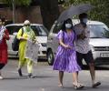
As Mumbai grapples with rising temperatures and humidity, many slum dwellers are spending their nights on Versova beach to escape the unbearable heat in their poorly ventilated homes, with the India Meteorological Department (IMD) forecasting a gradual rise in temperatures before a decline, and a yellow alert for isolated rainfall.

Several districts in Uttar Pradesh experienced rainfall, with Kanpur City recording the highest precipitation. The India Meteorological Department reported a drop in temperatures across the state, including Lucknow, and issued a forecast for continued rain in western UP.

India is likely to witness a mixed temperature pattern along with wetter-than-usual conditions in May, with the India Meteorological Department (IMD) indicating that rainfall across the country is "most likely to be above normal" at over 110 per cent of the long period average (LPA).
Maximum temperatures dropped below 40 degrees Celsius in several areas of Punjab, providing slight respite to residents from the intense heat. Haryana continued to experience hot weather, with Rohtak being the hottest spot at 45.3 degrees Celsius.

'During the hot season (April to June), above-normal minimum temperatures are likely over most parts of the country, except in some regions of Maharashtra and Telangana, where minimum temperatures are expected to be normal to below normal,' IMD said.

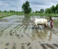
The India Meteorological Department (IMD) has forecasted an early onset of the southwest monsoon over Kerala, expected around May 26. This marks the beginning of the crucial rainy season for India.

'We should expect extreme heat, extreme rains, floods, landslides and maybe cyclones. Not just this year, in the coming year as well.'

Delhi experienced a foggy morning with a dip in temperature and improved air quality following recent rainfall. The air quality index (AQI) reached 'satisfactory' levels for the first time in five months.

'Monsoon is the pran (life) of our water system.' 'A weak monsoon will have a very negative impact on crops and people's lives.'

Several states in north India, including Rajasthan and Himachal Pradesh, experienced varied weather conditions, including light to moderate rainfall, fog, and temperature fluctuations.

Delhi recorded its coldest January morning in three years with the minimum temperature dropping to 3 degrees Celsius. Cold wave conditions are expected to persist, and air quality has deteriorated to the 'very poor' category.

Above-normal cold wave days are expected in some areas of central India, eastern Uttar Pradesh and Bihar during January 2026.

The winters could be cooler in the plains due to the prevailing La Nina conditions though it does not have a direct relationship and also due to influence of the polar vortex.

Delhi experiences a biting chill with 'cold day' conditions and dense fog, coupled with 'very poor' air quality. The IMD forecasts continued cold weather and potential light rain.

The India Meteorological Department (IMD) has predicted above-normal rainfall across India in June, with most parts of the country likely to experience normal to below-normal maximum temperatures. The IMD also anticipates above-normal minimum temperatures across most of the country, except for some parts of central India and the adjoining south peninsula. The southwest monsoon reached Kerala on May 24, marking its earliest arrival over the Indian mainland since 2009. The monsoon is crucial for India's agriculture-dependent economy, providing vital water for crops and supporting drinking water and hydropower generation.

A severe cold wave has intensified across North India, with Delhi recording its lowest temperature of the season. Rajasthan experienced sub-zero temperatures, and several states have issued alerts and closed schools due to the extreme conditions.

The national capital was in the grip of a cold wave, with the sun largely obscured by clouds and pollutants lingering in the atmosphere, leading to reduced visibility. At least 129 flights were cancelled at the Delhi airport on Saturday due to dense fog, according to an official.

A thick layer of toxic smog enveloped the national capital on Saturday as air quality deteriorated sharply, prompting the Commission for Air Quality Management (CAQM) to invoke the strictest curbs under Stage IV of the Graded Response Action Plan (GRAP) across Delhi-NCR.

The record monsoon rains across India during the June to September months was 937.2 millimetres, the 5th-highest since 2001 and 38th-highest since 1901.

The India Meteorological Department (IMD) has predicted above-normal rainfall for most parts of India during the post-monsoon season (October to December), except for some areas in the northwest. The southwest monsoon season ended with the country recording eight per cent above normal rainfall.

India is likely to experience below-normal monsoon rainfall this year, with a 20 per cent chance of drought due to the end of La Nina conditions and the potential for El Nino to take hold, private forecasting agency Skymet Weather said on Monday.

Heatwave may abate over most parts of North India in next two days; temperatures likely to drop by 2-3C.

The IMD has red and orange alerts for the hours ahead.

At the review meeting, chaired by cabinet secretary Rajiv Gauba in New Delhi, the IMD said above normal maximum temperatures are likely over most parts of northeast, east and central India and some parts of northwest India.

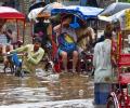
Heavy rain lashed Delhi, leading to waterlogging and traffic disruptions. The IMD issued an 'orange' alert, warning of more rainfall.
The early onset of the southwest monsoon brought continuous rainfall across southern and eastern India, contributing to this record.
The India Meteorological Department (IMD) forecasts above-normal rainfall for India in September, following a monsoon season marked by heavy downpours and related disasters in various regions. The forecast indicates normal to above-normal rainfall for most areas, with some exceptions in the northeast, east, extreme south peninsular India, and parts of northwest India.

The cold wave days in December too are expected to be 'below-normal' this year.

The January of 1919 recorded 15 degree Celsius and it remains the warmest January so far. "So January 2021 has also become the warmest in 62 years after 1958," the IMD said.
India is expected to experience hotter-than-usual temperatures from April to June, with more heatwave days in central and eastern India and the northwestern plains, the IMD said. Most parts of the country will see higher-than-normal maximum temperatures, except for some areas in western and eastern India where the temperatures are expected to be normal. Minimum temperatures will also be above normal in most regions. The IMD has warned that landslides could occur in parts of Kerala and Karnataka in the Western Ghats and that northeastern states might face flooding in April.

The India meteorological department said another western disturbance is likely to bring storms and rain to the northern plains, including Delhi, over the next few days.

The India Meteorological Department (IMD) has predicted above-normal rainfall for the upcoming monsoon season in India (June to September). The cumulative rainfall is estimated to be 105 percent of the long-period average. The IMD has also ruled out the possibility of El Nino conditions during the entire season. The monsoon is crucial for India's agriculture sector, which supports the livelihood of a significant portion of the population and contributes substantially to the country's GDP. However, while the prediction of normal rainfall brings relief, climate change is expected to cause variations in rainfall distribution.

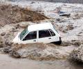
A strong dust storm and gusty winds followed by rain hit Delhi-NCR on Friday evening, causing trees to be uprooted in several parts and leading to traffic congestion. Thunderstorms caused power disruptions in several parts of the city, primarily due to trees and branches falling on electricity cables. The India Meteorological Department (IMD) has issued an orange alert, recommending people stay indoors and avoid unnecessary travel.

A cold wave has intensified in most parts of north India, with temperatures in the Kashmir Valley dipping below freezing point. The national capital saw a brief respite from the bitter cold during the day, but cold conditions persisted in parts of Rajasthan and Himachal Pradesh. The weather department has issued a yellow warning for cold wave, ground frost and dense fog for some places in Himachal Pradesh. There is a possibility of rain and snowfall in parts of northwest India later in the week.

A cold wave has gripped many parts of north and east India, with Srinagar recording a minimum temperature of minus 5.3 degrees Celsius. Other areas experiencing below-freezing temperatures include Gulmarg, Pahalgam, Konibal, Qazigund, Kupwara, and Kokernag in Kashmir. Himachal Pradesh has issued an orange warning for severe cold wave conditions in several districts. Delhi recorded a minimum temperature of 5.9 degrees Celsius, while Faridkot in Punjab was the coldest in the region at 0 degrees Celsius. Extreme cold conditions also continued in parts of Rajasthan and Jharkhand. The Met office has forecast mainly dry weather until December 26, with the possibility of light snowfall in the higher reaches of Kashmir on the intervening night of December 21-22.

Dense fog blanketed parts of Delhi on Wednesday morning, reducing visibility and disrupting over 100 flights and 26 trains. The India Meteorological Department (IMD) reported minimum visibility of 200 metres in moderate fog at Safdarjung and 150 metres in dense fog at Palam. The IMD has issued an orange alert for Delhi, with dense to very dense fog reported in several areas. Cloudy skies are expected throughout the day, with light rain or drizzle likely in some areas.